
Dear Bicycle Board Members,
We’ll finish Thursday’s meeting a lot quicker if everyone shows up already familiar with the map at https://drive.google.com/open?id=1KdzWWW29ZXA3B4ZnTBQgb-ZWwJIHLJRa&usp=s... https://drive.google.com/open?id=1KdzWWW29ZXA3B4ZnTBQgb-ZWwJIHLJRa&usp=sharing . It shows a preliminary complete bicycle infrastructure for Morgantown.
GO AHEAD. OPEN IT NOW! :) You’ll have to zoom in to see detail (click the + sign in the lower right corner).
The map has 11 layers that you can turn on or off by clicking the check box beside each layer’s name. The layers are: - Proposed Climbing Lanes - Proposed On-Road Bike Routes - Unconventional On-Road (or in Parking Lot) Routes - Proposed Off-Road Paths / Trails - Unavoidable State-Owned Routes - Useful Points of Interest - Parking Mousing over the items in any lay that you’ve turned on will “light up” the items in that layer.
If you’re like me, once you’ve explored the map this far, nobody has to tell you to dig deeper! You’ll find yourself zooming in and out and navigating around to see what’s all there. Then, when we all show up for Thursday’s meeting, we’ll be ready to start working together to make this a reality!
Frank
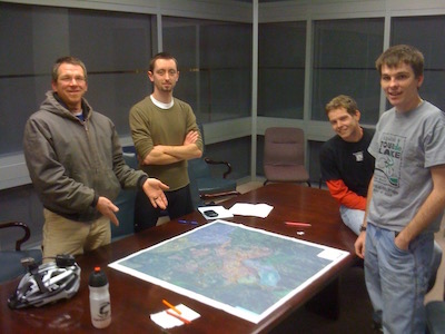
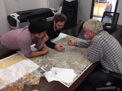
P.S. Drew spent countless hours creating this map starting last November after he, Chip, Jing and I worked on identifying bike routes to be signed. As you know, the BB has been working on maps, markings and signs for more than 10 years and this is the first look that expands beyond the roads and the rail trail.
MORE FUN!
What route would you take to ride your bike from your residence to the Apothecary Ale House & Cafe? Follow it on the map on the Morgantown Bike Spine Network https://drive.google.com/open?id=1KdzWWW29ZXA3B4ZnTBQgb-ZWwJIHLJRa&usp=sharing and see what proposed amenities you’d encounter. TELL US WHAT YOU DISCOVER at the BB meeting tomorrow.
For example, according to the map, if I go the way I usually go from my house in Greenmont, I would travel on Wilson Av., (a Proposed Bike Route); Green St.; Watts St.; Kingwood St.: Cobun Av. (an Unconventional On-Road (or in Parking Lot) Route… huh? South Walnut St. (an Unconventional On-Road (or in Parking Lot) Route… huh? Walnut St. Bridge (an Unavoidable State-Owned Route) [but now, there’s the new Greenmont Bicycle Bridge]; Walnut St.; High St.; Chancery Row (across a Proposed Shared Lane (Sharrows & BMUFL Signs) on Chestnut St.).
While doing this exercise, I noticed that I omitted the names of 3 layers in the list of layers in my previous message: - Proposed Shared Lanes (Sharrows / BMUFL); - Existing Car-Free Paths and - Obstacles / Conflict Points. Sorry!
This exercise led me to wonder why Cobun Av. and South Walnut St. are marked as Unconventional On-Road or in Parking Lot Routes. It also inspired me to explore a route using the new Greenmont Bicycle Bridge and to imagine what it would be like to ride up the someday to be restored Decker Av. to Spruce St. and get to the Apothecary from there.
Almost as much fun as riding a bike on this hot day but still good enough to generate a healthy thirst;)
Frank
On Sep 3, 2018, at 1:38 PM, Frank Gmeindl fgmeindl@gmail.com wrote:
Dear Bicycle Board Members,
We’ll finish Thursday’s meeting a lot quicker if everyone shows up already familiar with the map at https://drive.google.com/open?id=1KdzWWW29ZXA3B4ZnTBQgb-ZWwJIHLJRa&usp=s... https://drive.google.com/open?id=1KdzWWW29ZXA3B4ZnTBQgb-ZWwJIHLJRa&usp=sharing . It shows a preliminary complete bicycle infrastructure for Morgantown.
GO AHEAD. OPEN IT NOW! :) You’ll have to zoom in to see detail (click the + sign in the lower right corner).
The map has 11 layers that you can turn on or off by clicking the check box beside each layer’s name. The layers are:
- Proposed Climbing Lanes
- Proposed On-Road Bike Routes
- Unconventional On-Road (or in Parking Lot) Routes
- Proposed Off-Road Paths / Trails
- Unavoidable State-Owned Routes
- Useful Points of Interest
- Parking
Mousing over the items in any lay that you’ve turned on will “light up” the items in that layer.
If you’re like me, once you’ve explored the map this far, nobody has to tell you to dig deeper! You’ll find yourself zooming in and out and navigating around to see what’s all there. Then, when we all show up for Thursday’s meeting, we’ll be ready to start working together to make this a reality!
Frank
P.S. Drew spent countless hours creating this map starting last November after he, Chip, Jing and I worked on identifying bike routes to be signed. As you know, the BB has been working on maps, markings and signs for more than 10 years and this is the first look that expands beyond the roads and the rail trail.
<IMG_0210.jpg> <IMG_4169 copy.jpg>
Excellent work! I cannot attend tonight, but am happy to help add to this map as I ride. I've been adding to the rackspotter parking page as well. Noted on my ride home yesterday, sharrows have been installed on University Ave in the uphill lane in Sunnyside heading toward Suncrest. I think I saw them in the uphill lane from Patteson toward Evansdale as well until the climbing lane starts. I've ridden the climbing lanes on University & Richwood...nice to see progress on pavement! Request: I'm finalizing a first draft of a bicycle safety survey to be distributed by a WVU class in ER & Urgent Care waiting rooms during the second half of this semester. May I get 2 or 3 volunteers from the board to review a draft next week? It'll be a survey about perceived safety in town, perceptions of different types of infrastructure, bike culture, and more. Designed for road riders, non-riders, and the "interested but concerned" rider. It can be used to help the board if you'd like. Please email me if interested. Thanks!Christiaan "When the spirits are low, when the day appears dark, when work becomes monotonous, when hope hardly seems worth having, just mount a bicycle and go out for a spin down the road, without thought on anything but the ride you are taking.” -Sir Arthur Conan Doyle
On Monday, September 3, 2018, 1:38:35 PM EDT, Frank Gmeindl via Bikeboard bikeboard@bikemorgantown.com wrote:
Dear Bicycle Board Members, We’ll finish Thursday’s meeting a lot quicker if everyone shows up already familiar with the map at https://drive.google.com/open?id=1KdzWWW29ZXA3B4ZnTBQgb-ZWwJIHLJRa&usp=s.... It shows a preliminary complete bicycle infrastructure for Morgantown. GO AHEAD. OPEN IT NOW! :) You’ll have to zoom in to see detail (click the + sign in the lower right corner). The map has 11 layers that you can turn on or off by clicking the check box beside each layer’s name. The layers are:- Proposed Climbing Lanes- Proposed On-Road Bike Routes- Unconventional On-Road (or in Parking Lot) Routes- Proposed Off-Road Paths / Trails- Unavoidable State-Owned Routes- Useful Points of Interest- ParkingMousing over the items in any lay that you’ve turned on will “light up” the items in that layer. If you’re like me, once you’ve explored the map this far, nobody has to tell you to dig deeper! You’ll find yourself zooming in and out and navigating around to see what’s all there. Then, when we all show up for Thursday’s meeting, we’ll be ready to start working together to make this a reality! Frank P.S. Drew spent countless hours creating this map starting last November after he, Chip, Jing and I worked on identifying bike routes to be signed. As you know, the BB has been working on maps, markings and signs for more than 10 years and this is the first look that expands beyond the roads and the rail trail.
_______________________________________________ Bikeboard mailing list Bikeboard@bikemorgantown.com http://wvcompletestreets.org/mailman/listinfo/bikeboard
-
 Christiaan Abildso via Bikeboard
 -
Frank Gmeindl via Bikeboard